
Use the options below to change Calendar style or filter by category. Always check Race Organiser’s website for full and up-to-date race information.
8 x 800m efforts.
Route – Rodley, Calverley, Thornbury (distance 8.5 miles)
- Start time info: Women’s start 13;00, men’s 13:15
- Region: North York Moors
- Category: AM
- GPS:

- Website: www.eskvalleyfellclub.org
- Distance: 15.9km / 9.9m
- Climb: 800m / 2625ft
- Skills & experience: ER, PM, LK, NS
- Minimum age: 18
- Entry info: Entries via Si Entries to open on 1st February to 29th March
English Championship counter, Yorkshire Senior Championship and Yorkshire U23 race
New course remodeled from the old 2015 championship event; details of course will be posted on website.
The route is on rights of way so recce is allowed.
Parking at Belmont house,Rectory lane, TS147FD; no parking at registration -10 mins walk.
Changing and toilets at registration hall along with refreshments for a nominal fee towards sea cadets funds.
Cleveland mountain rescue are assisting with all money raised going to them
Distance – 8.75 miles
Efforts – 5 x 1 mile efforts
Route – Through Farsley, down to The Owl pub at Rodley, up Coal Hill Lane, along Intake/Swinnow through Stanningley, to Pudsey centre, then down to Fartown before heading back to the school.
- Region: York. Dales
- Category: AS

- Website: www.bofra.org.uk
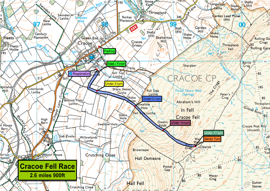
- Distance: 4.2km / 2.6m
- Climb: 274m / 899ft
- Minimum age: 17
Littondale Fete 4 Mile Road Race – 1pm
Entry: https://www.race-results.co.uk/results/2021/
BOFRA – junior races start at 2pm (Seniors should be around 3:30)
Pre-registration required if not a BOFRA member
- Region: York. Dales
- Category: AS
- Website: www.wharfedaleharriers.co.uk
- Distance: 6.5km / 4m
- Climb: 475m / 1558ft
- Grid ref: 975726
- Skills & experience: PM, LK
- Minimum age: 16
Incorporating the Yorkshire Senior and Under 23 Championships 2021
Distance – 8.75 miles
Efforts – 5 x 0.75 to 1 mile efforts (approx)
Route – Through Farsley, down to The Owl pub at Rodley, up Coal Hill Lane, along Intake/Swinnow through Stanningley, to Pudsey centre, then down to Fartown before heading back to the school.
- 2nd entrance to Westroyd Park to Springbank Rd/Coal Hill Ln/Bagley Rd junction
- Pedestrian crossing (just after Club Ln) to Top of Coal Hill Ln/Intake Ln junction
- Bus stop after the bypass bridge to The Britannia Pub
- Corner/bend on Littlemoor Rd (building that used to be a pub opposite Busy Bees) to top of Fartown where it becomes Greenside
- The Marsh Pub to round about at Bradford Rd (A647)

Distance – 8.2 miles
Efforts – 4 x 1.5 miles (ish)
Route – Down to Stanningley, up Broad lane to Bramley Town Street, down Henconner Ln (past bus depot) to Wickes, up Pudsey Rd to Pudsey centre, on to Uppermoor, then Waterloo Rd and back to the start
Start/finish points for efforts:
- Viaduct Richardshaw Lane to shops by Beacon Pub on Broad Lane
- Opposite Methodist Church on Upper Town Street to Bridge (under train track) on Henconner Lane
- Just after lights on Pudsey road (“Pudsey Speed Watch” sign on left) to Pudsey centre/Pudsey Town Hall traffic lights
- The Marsh pub to the last bus stop on Bradford Road before the Dawsons Corner roundabout

Distance – 8.75 miles
Efforts – 5 x 0.75 to 1 mile efforts (approx)
Route – Through Farsley, down to The Owl pub at Rodley, up Coal Hill Lane, along Intake/Swinnow through Stanningley, to Pudsey centre, then down to Fartown before heading back to the school.
- 2nd entrance to Westroyd Park to Springbank Rd/Coal Hill Ln/Bagley Rd junction
- Pedestrian crossing (just after Club Ln) to Top of Coal Hill Ln/Intake Ln junction
- Bus stop after the bypass bridge to The Britannia Pub
- Corner/bend on Littlemoor Rd (building that used to be a pub opposite Busy Bees) to top of Fartown where it becomes Greenside
- The Marsh Pub to round about at Bradford Rd (A647)
Distance – 8.2 miles
Efforts – 4 x 1.5 miles (ish)
Route – Down to Stanningley, up Broad lane to Bramley Town Street, down Henconner Ln (past bus depot) to Wickes, up Pudsey Rd to Pudsey centre, on to Uppermoor, then Waterloo Rd and back to the start
Start/finish points for efforts:
- Viaduct Richardshaw Lane to shops by Beacon Pub on Broad Lane
- Opposite Methodist Church on Upper Town Street to Bridge (under train track) on Henconner Lane
- Just after lights on Pudsey road (“Pudsey Speed Watch” sign on left) to Pudsey centre/Pudsey Town Hall traffic lights
- The Marsh pub to the last bus stop on Bradford Road before the Dawsons Corner roundabout